.jpg)

Last month, transportation practitioners gathered at Replica’s User Summits in both San Francisco and Los Angeles to share how they are applying Replica’s mobility, demographic, and safety data and applications to real planning and operational challenges. The presentations and discussions made clear that Replica has become increasingly central to agencies’ workflows, from planning for evacuation scenarios to prioritizing safety investments.
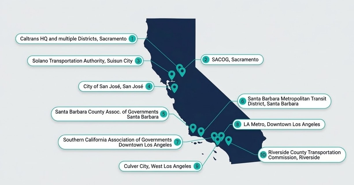
A Strong Public Agency Presence Across the State
Attendance spanned state, regional, and local agencies, reflecting the breadth of Replica’s engagement across California’s transportation ecosystem.
The conversations reflected a wide range of operational realities, from statewide corridor planning to city-level safety analysis. Contributions from consulting partners working alongside these agencies reflected the collaborative nature of many planning efforts across the state.
Replica Embedded in Workflows
The core of each summit was a set of practitioner-led presentations, where each speaker described how Replica’s data and purpose-built applications are being applied to active projects with real planning and funding implications.
NorCal Spotlights
At the San Francisco summit, presentations covered a range of use cases that illustrate how Replica’s mobility and demographic data and scenario tooling supports different phases of the planning lifecycle.
Natalie Amberg from Caltrans’ Division of Data and Digital Services presented work analyzing commuter flows between Metrolink stations, comparing auto and transit mode shares and mapping corridor-level origin-destination patterns. The analysis is supporting connectivity assessments and investment prioritization across the state’s rail network.
Anais Schenk from Kimley-Horn demonstrated how they are using Replica’s Road Closure Scenarios application, a scenario modeling tool built on Replica’s mobility data, to evaluate how planned construction closures affect regional mobility. The team identified critical corridors and bottlenecks, quantified impacts to VMT and commute patterns, and assessed community impacts through affected origin destination pairs, supporting clearer construction coordination and permitting decisions without the time and complexity of traditional microsimulation.
Ayberk Kocatepe, also from Kimley-Horn, shared their work with evacuation planning using Replica data. Using Replica’s agent-based mobility data, the team can simulate evacuations for hazards such as wildfire, flooding, earthquakes, and hurricanes, estimating clearance times, bottlenecks, and evacuation volumes. Replica’s data and solutions also allow them to test scenarios such as contra-flow operations, phased evacuations, and road closures, helping agencies evaluate evacuation strategies through transparent, defensible analysis.
Ava Wright and Catalina Foster from Caltrans District 5 shared their work on the SR 17 Comprehensive Multimodal Corridor Plan, where Replica mobility insights are being integrated directly into the plan’s climate resiliency and emergency management chapters. This work highlights how Replica is integrated into formal planning processes in district-level inititiatives.
Kevin Johnson from RSG, Inc. shared why their firm trusts Replica data to deliver an accurate picture of mobility, even in rural places with historically limited data coverage. Replica was used to support a regional travel model update, improving model calibration, better representing existing land use patterns, and strengthening the reliability of long-range travel forecasts.
SoCal Spotlights
The Los Angeles summit featured presentations from Santa Barbara County Association of Governments, RSG, and Culver City.
Mia Lewis from SBCAG presented the agency’s Journey to Work Dashboard, which uses Replica data to analyze commuting patterns across Santa Barbara County. These insights support regional goals to reduce vehicle miles traveled, lower greenhouse gas emissions, and improve multimodal transportation planning.
Ali Ahmadi from RSG, Inc. expanded on the work that Kevin presented in San Francisco, demonstrating how Replica data can be used to analyze freight movement across multiple regions, helping planners understand truck activity and identify strategies to improve system resilience through data-driven analysis and stakeholder collaboration.
Andrew Maximous from Culver City demonstrated how the city is using Replica to support more proactive traffic engineering and safety analysis. The city is using Replica’s safety analysis solutions, which surface patterns in speeding, suspected collisions, near misses, and rapid acceleration events to target and measure the impact of safety interventions.
Across both summits, the pattern was clear: agencies are not using Replica simply as a dataset for occasional analysis. Instead, they are applying it directly to planning studies, travel model improvements, operational traffic analysis, construction scenario evaluation, and safety risk identification.
From Dataset to Solutions Platform
One of the clearest themes from the summits was the shift in how agencies are engaging with Replica.
In earlier years, conversations often focused on accessing mobility datasets and understanding travel patterns. Increasingly, agencies are engaging with applications built on top of those datasets to answer specific operational and planning questions.
Several capabilities highlighted at the summits reflect this shift:
- The California Corridor Planning Tool, developed in collaboration with Caltrans planners
- Before and After Intervention Analysis for measuring project impacts
- Safety Assessment and Corridor Prioritization tools
- Project Prioritization and Grants Management workflows
- Road Closure Scenarios for construction planning; and Evacuation Analysis capabilities for emergency preparedness
These tools reduce the amount of time agencies spend assembling datasets and allow planners to focus more directly on evaluating scenarios and making decisions.
Building a Shared Community of Practice in California
The breadth of participation across the summits reflect years of sustained engagement across California’s transportation ecosystem. Caltrans HQ and Districts, regional MPOs like SACOG and SBCAG, and cities like San Jose and Culver City, are applying Replica across planning, safety, and operations. Bringing these practitioners together creates an opportunity to share approaches, compare methods, and learn from projects happening across the state.
Thank you to all of the speakers, attendees, and agency partners who made these events possible. We look forward to continuing to build alongside you.
If your agency is exploring similar questions around travel behavior, safety, or corridor planning, we would welcome the opportunity to connect.